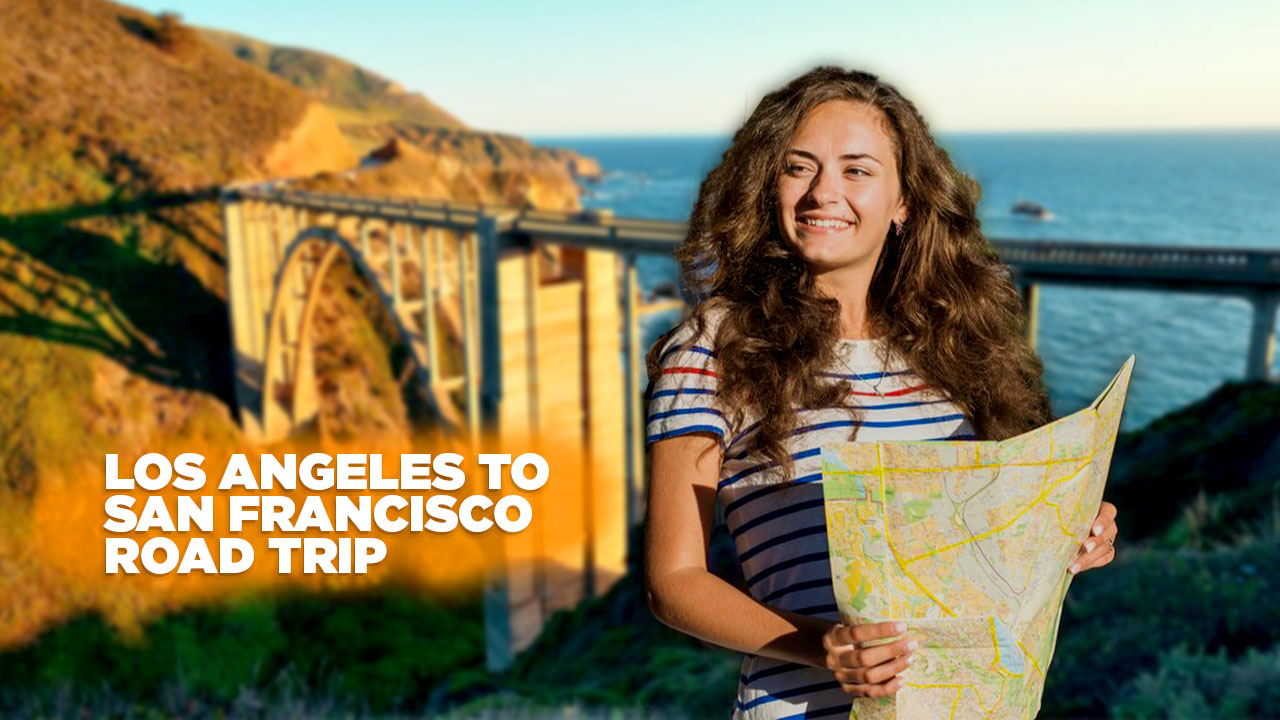
Planning a los angeles to san francisco road trip can feel hard when you try to choose stops along the Pacific Coast Highway. The route covers 588 miles of scenic road, from Santa Monica Pier past Malibu to the Golden Gate Bridge.
This guide shows must see spots, camper tips for a Kuga Campervan, and GPS tips with Google Maps to keep you on track each day. Your adventure awaits.
Key Takeaways
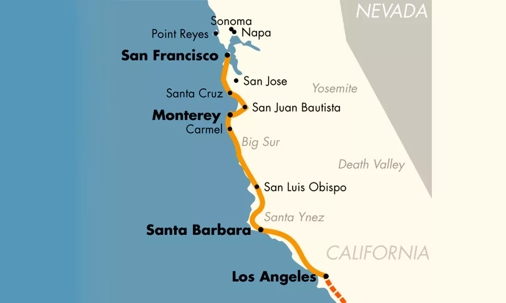
- The trip covers 588 miles from Santa Monica Pier to the Golden Gate Bridge in 5 days.
- Day 1: Santa Monica Pier to Santa Barbara. Day 2: Santa Barbara → Solvang (35 mi) → Pismo Beach → San Luis Obispo. Day 3: San Luis Obispo → Morro Bay (15 mi) → Hearst Castle (30 mi) → Elephant Seal Vista Point. Day 4: Big Sur → Bixby Creek Bridge (mile 185) → McWay Falls → Carmel → Monterey. Day 5: Monterey → Half Moon Bay (50 mi north of Santa Cruz) → San Francisco.
- Rent a Ford Kuga Campervan for four people or choose an SUV for extra cargo or a sedan for tight parking. Pack a sun hat, windbreaker, water bottle, snacks, power bank, and download Google Maps plus camping guides.
- Key stops: Hearst Castle’s Neptune Pool, Elephant Seal Vista Point, Bixby Creek Bridge, Julia Pfeiffer Burns State Park wildflowers, Monterey Bay Aquarium, Fisherman’s Wharf, Alcatraz, and Lombard Street.
- Best travel times are April–June or September–October to avoid summer fog and crowds, enjoy mild days, and find open campsites at Hearst Castle and along the Pacific Coast Highway.
Day 1: Los Angeles to Santa Barbara
You start at the Santa Monica Pier, grab sunrise shots with your action cam, and follow Highway 1 north with your sat-nav. You coast past surf culture in Venice Beach and roll into Santa Barbara’s old mission and palm-lined avenues.
Start at Santa Monica Pier
Cruise along Pacific Coast Highway to Santa Monica Pier. The jetty sits twenty miles west of Los Angeles. It features a Ferris wheel, amusement park games, and food stalls. Thrill seekers hop on rides, kids chase prize plushies at game booths.
One afternoon a friend won a goldfish at the ring toss. Street musicians strum guitar under a striped canopy. Shimmering sunsets light the bay near Venice Beach. This spot marks the launch of your coastal drive.
Explore Malibu’s scenic coastline
Start your drive at Santa Monica Pier. It lies 15 miles up Pacific Coast Highway. Zuma Beach offers wide sands and surf breaks. Malibu Farm sits on a pier and serves fresh fare.
Hike Solstice Canyon trail for sea views. This path cuts through oak woodlands and waterfall ruins. You spot sailboats on blue waves. Local guides show tide pools near hidden coves.
Visit Santa Barbara’s iconic landmarks
Santa Barbara sits 30 miles north of Ventura on the Pacific Coast Highway, with palm trees lining the way. State Street winds through downtown, dotted with art galleries, shops, and cozy cafes.
The Old Mission Santa Barbara greets visitors with white adobe walls, twin bell towers, and fragrant rose gardens. Stearns Wharf juts into the blue bay, where anglers cast lines and restaurants serve fresh seafood under sunlit skies.
Day 2: Santa Barbara to San Luis Obispo
You’ll hug the Pacific Coast Highway, swing into a fairy-tale town scented with fresh danishes. Then you chase sea mist to dune-lined Pismo Beach before rolling into San Luis Obispo’s sunlit plaza.
Stop by Solvang for Danish-inspired charm
A quick detour off Highway 1 brings you here. It sits 35 miles north of Santa Barbara. Whitewashed windmills spin in steady coastal breezes. Bakers offer fresh Danish pastries each morning.
Vineyards in the Santa Ynez Valley surround the hamlet. Tasting rooms pour crisp Chardonnays and robust Syrahs. Guests leave with pastry crumbs and wine-stained smiles.
Visit Pismo Beach for relaxation
Travelers find Pismo Beach near San Luis Obispo, just off the Pacific Coast Highway. Soft sand dunes stretch for miles, they invite bare feet and sea air. Splash Cafe serves hot clam chowder by the pier.
Each bowl packs thick broth, chunks of clam, and crispy bacon. The surf laps the shore, it soothes like a lullaby. Bring a picnic basket, let the sun draw out smiles. This seaside spot glows at sunset, it feels like a painting.
Explore San Luis Obispo’s downtown area
A stroll down Higuera Street reveals colorful murals, local bites, and vintage shops. You might spot Bubblegum Alley covered in thousands of chewed wads. Every Thursday morning a farmer’s market sets up in Mission Plaza.
Grab fresh figs, local cheese, or a fruity tart.
This lively core sits just 66 miles north of Solvang, right off the PCH. Mountains frame the town, and Bishop Peak looms like a green giant. You can cap your visit with a brew at a cozy taproom or catch live folk tunes in a plaza.
Day 3: San Luis Obispo to Big Sur
On Day 3, you’ll take the coastal route past Morro Bay, tour the grand hilltop estate, and watch elephant seals lounge at the overlook—read on to see what comes next.
Stop at Morro Bay for coastal views
Morro Bay sits 15 miles from San Luis Obispo along Highway 1. The rock rises above the water, like a giant sentry. Oyster shells crack underfoot at the Embarcadero. Shops line the waterfront.
Seafood grills steam prawns and clams. Surfers chase small waves near the bay.
You spot sea otters near Morro Rock with binoculars. You check your GPS and wander the beach for more sights. Crab stands offer fresh catches at old wharf huts. Continue north on the Pacific Coast Highway for jaw-dropping views in Big Sur.
Tour Hearst Castle in San Simeon
Hearst Castle stands above San Simeon along the Pacific Coast Highway. Guests must book tickets in advance for guided tours. The site lies 30 miles north of Morro Bay. William Randolph Hearst filled rooms with French tapestries and old master art.
Visitors walk through big halls and climb staircases to reach the Neptune Pool. Audio guides tell tales of movie stars and lavish parties. The gardens open to ocean views that stretch for miles.
The castle sits near Elephant Seal Vista Point on Highway One.
Visit Elephant Seal Vista Point
Drivers follow Pacific Coast Highway through Big Sur. Just 5 miles north of the castle at San Simeon built by William Randolph Hearst, you reach a gravel turnout. At this overlook, elephant seals gather on sandy shores, perfect for wildlife photography.
You watch them flop, snort, and sunbathe.
Families grin at the pups. A wooden boardwalk guides you past dunes. Binoculars help spot seals far out in the surf. Plan for slow traffic on the narrow lane. Crowds may swell at sunset.
Park in the small lot. Restrooms stand near the trailhead.
Day 4: Big Sur to Santa Cruz
Drive the Pacific Coast Highway over Bixby Bridge. Browse Carmel’s galleries, spy the kelp forests at the aquarium, then chase neon lights on the boardwalk.
Drive through the breathtaking Big Sur coastline
Pacific Coast Highway hugs sheer cliffs over crashing waves. This stretch lies 185 miles north of Elephant Seal Vista Point. Bixby Creek Bridge stands tall, its arches framing endless blue.
Tourists stop often, their cameras clicking by guardrails and rock faces.
Julia Pfeiffer Burns State Park awaits around the next bend. A short path leads visitors to an overlook near McWay Falls. Camera or smartphone both catch the swirl of salt and mist.
Cliffside breezes carry pine and ocean scents right into your car. Local artists call it a moving canvas, alive with light and foam.
Explore Carmel-by-the-Sea’s art galleries
Ocean Avenue hosts art galleries and boutique shops in two blocks. You can spot painters at work, chat about brush strokes over coffee. A drive along the Pacific Coast Highway drops you off 26 miles south of Big Sur.
Galleries show seascapes, landscapes, pop art, even mixed media. One painter quipped, “Carmel Beach at sunrise fuels my best work.” Menus of gallery maps rest on front desks. They guide visitors through studios, pottery spaces, glass artists.
Visit Monterey and the famous Cannery Row
Plan to pull off the Pacific Coast Highway (PCH) at Monterey, California, just 5 miles north of Carmel-by-the-Sea, cars line up beside old brick buildings. Shops and galleries fill the waterfront, restaurants turn former sardine sheds into tasty hot spots.
Cannery Row buzzes with artists hawking bright prints, families nosh on clam chowder, laughter echoes off the piers.
The Monterey Bay Aquarium tops most must-see lists, it thrills visitors with living kelp forests, sea otter pups, and open-ocean tanks. Grab your map app, aim for its address on historic docks, then stroll through glass tunnels that feel like submarine rides.
Pick a vantage point at the famed surf spot if you want to watch surfers chase waves later.
Day 5: Santa Cruz to San Francisco
You cruise the final miles on Pacific Coast Highway, with a map app and a paper atlas by your side. You glimpse the famous red span in the morning fog, then check out what the city by the bay has in store for you.
Stop at Half Moon Bay for coastal beauty
Half Moon Bay sits along the Pacific Coast Highway in Northern California, 50 miles north of Santa Cruz. Pumpkin farms dot the rolling hills and bright orange gourds line roadside stands.
Sandy beaches stretch under towering bluffs, and cold waves crash on wide sands. Ocean breezes fill the air with salt and pine.
Hikers tackle trails at Half Moon Bay State Park with a GPS app. Gentle paths climb through cypress groves and offer ocean views. Families explore rocky coves, spot sea stars in tide pools, and picnic near windswept dunes.
Surfers roll inshore, chasing cool swells.
End your trip in San Francisco with must-see attractions
The city sits 30 miles north of Half Moon Bay. You follow Highway 101 or Pacific Coast Highway toward the bay. You cross the Golden Gate Bridge by bike or car and feel the wind at your back.
Cable cars climb steep streets and deliver you to Fisherman’s Wharf. Alcatraz looms in the water, and a boat tour takes you close to those old cell blocks. Art fans flock to the Painted Ladies at Alamo Square.
Shops and murals line the Mission District, and a burrito here rivals any coastal view. You can snap a pic at Lombard Street’s crooked curves.
Tips for Planning Your Road Trip

Grab a map and a navigation device to find fuel stops, beach breaks, or village rests. Read on for gear lists, timing tips, and hidden coastal routes.
Best time to visit
Spring and fall bring mild days along the Pacific Coast Highway. You cruise under clear skies, hit Bixby Bridge at sunrise. Winds stay gentle at Half Moon Bay and Santa Cruz. Wildflowers bloom in Julia Pfeiffer Burns State Park.
You dodge summer traffic in Santa Barbara and Big Sur. Flight deals from Chicago and Fort Lauderdale land you in Los Angeles for under $75 roundtrip per person. Trip stays ideal for campervan enthusiasts with open campsites and steady weather.
Plan trips from April to June or September to October. You score calm roads near Hearst Castle and Cannery Row. Forecast apps show low risk of morning fog. You glide past Carmel and the Santa Ynez Valley with ease.
Layers handle cool nights by the beach. This schedule suits solo explorers and families alike. Google Maps guides each twist on the coastal drive.
Recommended vehicle types
Kuga Campervan makes your Pacific Coast Highway trip easy. It holds four people and stores coolers, surfboards, camping gear. The design fits a kitchenette, fridge, and sink. Travelers Autobarn offers rentals in Los Angeles, Las Vegas, San Francisco, Denver, and Seattle.
Drivers steer past Santa Barbara’s old mission, roll onto Big Sur’s winding road, camp near Julia Pfeiffer Burns State Park without fuss.
Some travelers grab an SUV for extra trunk space. A mid-size crossover lets you pack beach chairs for Santa Cruz beach boardwalk or picnic baskets for Half Moon Bay. Sedan drivers enjoy tighter parking spots at Fisherman’s Wharf and Cannery Row.
GPS units and road atlas tools keep you on track toward Hearst Castle, Morro Bay, or the Painted Ladies.
Essential items to pack
Choose a carry-on over a suitcase. It helps skip long waits at Los Angeles baggage claim. Pack a water bottle, snacks, and a power bank for your ride on the Pacific Coast Highway. Tuck in a sun hat, windbreaker, and compact layers for chilly mornings at Old Mission Santa Barbara and foggy roads through Big Sur.
Download the Beginner’s guide to traveling the USA, the Guide to free camping in the USA, and the Guide to the best campgrounds in the USA to your phone.
Conclusion
Your long haul on the coastal road fills pages with tales, sun, and fun. This guide lays out route tips, van hacks, and top stops. You grab a map app or sat nav, and head out. Each beach, cliff view, and boardwalk stop sparks a fresh memory.
The trip peaks at a sweeping Golden Gate Bridge shot. Go claim that California glow, swirl in the salt breeze, and yield to the road’s charm.
FAQs
1. What is the best time to start a Los Angeles to San Francisco road trip?
Start in Los Angeles before dawn, watch the sky blaze at Santa Monica Pier, spot surfers at Venice Beach, then cruise the Pacific Coast Highway.
2. Which key stops should I hit on the Pacific Coast Highway route?
Begin in Santa Barbara at the Old Mission, sip wine in Santa Ynez Valley, explore Hearst Castle near San Luis Obispo, then roll into Big Sur, cross Bixby Bridge, and view McWay Falls in Julia Pfeiffer Burns State Park. Later, wander Cannery Row by Monterey Bay Aquarium, ride the Santa Cruz Beach Boardwalk, and snap painted ladies in San Francisco.
3. How many days make a solid drive?
Plan four days. Camp by Pismo Beach first. Then dive into the Funk Zone in Santa Barbara. Hit Steamer Lane in Santa Cruz on day three, and save day four for Half Moon Bay, Fisherman’s Wharf, and the Golden Gate Bridge.
4. Can I find cheap stays on the way?
Yes, you can. Try motels in San Buenaventura or hostels in Santa Cruz. Look for farm stays in Santa Ynez Valley, or share a room in the Mission District if you dare.
5. Is it worth a detour to Santa Cruz or Huntington Beach?
Pismo Beach is a hidden gem. Santa Cruz feels like a classic fair by the sea. Huntington Beach sits on the west coast of the United States with endless waves. Each spot sparks smiles.
6. How do I skip the worst traffic near the Golden Gate Bridge?
Cross at dawn or late at night to miss the jam. If you get stuck, duck into the Mission District for killer tacos and fresh art while you wait.